


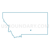
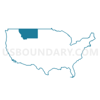
Billings City PUMA, Montana
About
Outline

Summary
| Unique Area Identifier | 193322 |
| Name | Billings City PUMA |
| State | Montana |
| Area (square miles) | 49.16 |
| Land Area (square miles) | 48.33 |
| Water Area (square miles) | 0.83 |
| % of Land Area | 98.32 |
| % of Water Area | 1.68 |
| Latitude of the Internal Point | 45.78941680 |
| Longtitude of the Internal Point | -108.54349640 |
Maps
Graphs
Select a template below for downloading or customizing gragh for Billings City PUMA, Montana


Neighbors
Neighoring Public Use Microdata Area (by Name) Neighboring Public Use Microdata Area on the Map
Top 10 Neighboring County (by Population) Neighboring County on the Map
Top 10 Neighboring County Subdivision (by Population) Neighboring County Subdivision on the Map
- Billings CCD, Yellowstone County, MT (107,934)
- Laurel CCD, Yellowstone County, MT (15,847)
- South Yellowstone CCD, Yellowstone County, MT (7,653)
- Northwest Yellowstone CCD, Yellowstone County, MT (7,558)
- Shepherd CCD, Yellowstone County, MT (4,540)
Top 10 Neighboring Place (by Population) Neighboring Place on the Map
Top 10 Neighboring Elementary School District (by Population) Neighboring Elementary School District on the Map
- Billings Elementary School District, MT (107,977)
- Lockwood Elementary School District, MT (7,865)
- Independent Elementary School District, MT (2,624)
- Blue Creek Elementary School District, MT (2,111)
- Canyon Creek Elementary School District, MT (1,921)
- Elysian Elementary School District, MT (1,084)
- Pioneer Elementary School District, MT (913)
Top 10 Neighboring Secondary School District (by Population) Neighboring Secondary School District on the Map
Top 10 Neighboring State Legislative District Lower Chamber (by Population) Neighboring State Legislative District Lower Chamber on the Map
- State House District 46, MT (13,942)
- State House District 57, MT (11,941)
- State House District 47, MT (10,977)
- State House District 48, MT (10,702)
- State House District 55, MT (10,488)
- State House District 56, MT (10,028)
- State House District 44, MT (9,744)
- State House District 51, MT (9,206)
- State House District 54, MT (9,182)
- State House District 49, MT (8,803)
Top 10 Neighboring State Legislative District Upper Chamber (by Population) Neighboring State Legislative District Upper Chamber on the Map
- State Senate District 23, MT (23,380)
- State Senate District 29, MT (22,035)
- State Senate District 24, MT (21,679)
- State Senate District 28, MT (20,516)
- State Senate District 22, MT (19,347)
- State Senate District 26, MT (17,992)
- State Senate District 27, MT (17,876)
- State Senate District 25, MT (17,366)
Top 10 Neighboring 111th Congressional District (by Population) Neighboring 111th Congressional District on the Map
Top 10 Neighboring Census Tract (by Population) Neighboring Census Tract on the Map
- Census Tract 14.01, Yellowstone County, MT (9,227)
- Census Tract 9400, Yellowstone County, MT (7,653)
- Census Tract 7.02, Yellowstone County, MT (7,400)
- Census Tract 13, Yellowstone County, MT (6,124)
- Census Tract 18.02, Yellowstone County, MT (5,952)
- Census Tract 14.02, Yellowstone County, MT (5,634)
- Census Tract 9.02, Yellowstone County, MT (5,389)
- Census Tract 18.01, Yellowstone County, MT (5,321)
- Census Tract 11, Yellowstone County, MT (5,315)
- Census Tract 17.03, Yellowstone County, MT (5,275)